

KL International Airport
IATA/ICAO code
KUL/WMKK
Latitude
02°44'44.08" N
Elevation
69ft / 21m
Longitude
101°42'35.70" E
Runway
3
Capacity
75.0 mppa
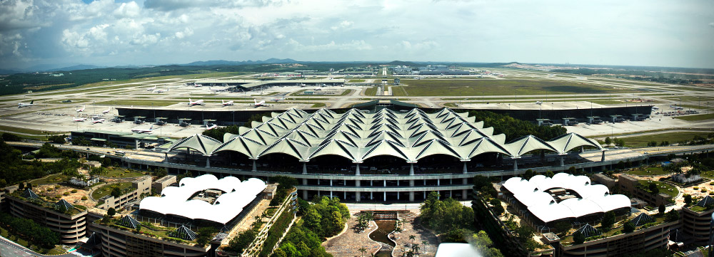
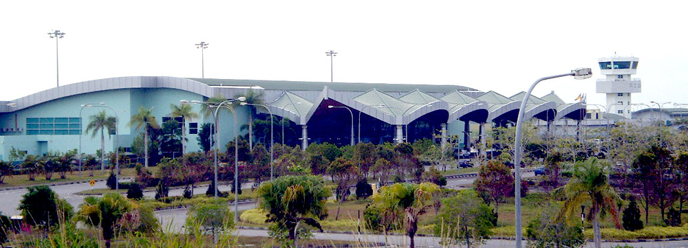
Opened in 1998, KL International Airport (KLIA) is one of the region’s major aviation hubs. Located on the west coast of Peninsula Malaysia, bordering the states of Selangor and Negeri Sembilan, the airport is approximately 50 km from Malaysia’s capital city, Kuala Lumpur. A good network of highways and expressways links KLIA to the rest of Peninsula Malaysia. It was first built with a capacity of 25 mppa with two independent Runway, the Main Terminal has since been optimised to handle up to 30 mppa.
In May 2014, its second terminal, Terminal 2, was opened just 2 km away from KLIA’s Main Terminal. Built with a capacity of 45 mppa, Terminal 2 is also accessible via the same network of highways and expressways that links the airport to surrounding major cities.
KLIA possesses world standard facilities and is equipped to accommodate the Airbus A380, the world’s largest passenger aircraft. A huge variety of international and local retail brand and duty-free outlets, cafés, restaurants, as well as premium passenger lounges are available at the airport for your travelling convenience and comfort. It is a passenger-friendly airport with facilities to ease the flow of passengers, keep you entertained while waiting for your flights and provide a seamless travelling experience for everyone.
KLIA has three independent Runway that run at approximately 4,000 m length each to serve both the Terminal 1 and Terminal 2. The airport caters to more than 60 airlines, as well as serves more than 120 direct destinations and more than 1,000 indirectly.
Apart from travelling by car or other modes of public transportation to go to KLIA, passengers can ride the high-speed train KL Ekspres or KLIA Transit by Express Rail Link (ERL). Both KLIA Ekspres and KLIA Transit connect KLIA from the City Air Terminal (CAT) at KL Sentral, where departing passengers can check-in for their outbound flights before boarding the train for KLIA. Travel time between KL Sentral and KLIA’s Main Terminal Building is only 28 minutes on the KLIA Ekspres and 37 minutes on the KLIA Transit. Passengers can get to Terminal 2 from Terminal 1 via a 3-minute inter-terminal train ride with the same ERL system, or via the inter-terminal airport shuttle bus.
Kota Kinabalu International Airport

IATA/ICAO code
BKI/WBKK
Latitude
05°56'13.95"N
Elevation
10ft / 3m
Longitude
116°03'04.25"E
Runway
1
Capacity
9.0 mppa
Located 8 km from the city of Kota Kinabalu, the state capital of Sabah, the airport acts as the main gateway into Sabah and Borneo. Formerly known as Jesselton Airfield during World-War II, the airport has gone through various phases of upgrade. Today, it is the second busiest airport in Malaysia after KL International Airport. The airport has a variety of retail and duty-free outlets, cafés and restaurants, as well as premium passenger lounges for your travelling convenience and comfort. It has a single runway and is equipped to handle wide body aircraft such as the Airbus A380 and Boeing 747.
Kuching International Airport

IATA/ICAO code
KCH / WBGG
Latitude
01°29'04.91" N
Elevation
89ft / 27m
Longitude
110°20'48.96" E
Runway
1
Capacity
5.3 mppa
Built by the British in the 1940's, Kuching International Airport (KCH) has since become a gateway to the state of Sarawak as well as Brunei. KIA is located 11km south of the city of Kuching. The airport's terminal is capable of handling 5.3 million passengers annually, making it the fourth busiest airport in Malaysia. It can also accommodate wide body aircraft such as the Airbus A380 and Boeing 747. The airport has a variety of retail and duty-free outlets, cafés and restaurants, as well as premium passenger lounges for your travelling convenience and comfort. The airport is also an airbase for the Royal Malaysian Air Force (RMAF).
Langkawi International Airport

IATA/ICAO code
LGK / WMKL
Latitude
06°19'47.02" N
Elevation
29ft / 9m
Longitude
099°43'43.20" E
Runway
1
Capacity
4.0 mppa
Langkawi International Airport (LGK) is situated on the duty-free island of Langkawi in Kedah. The airport is located about 25-minutes' drive from Kuah Town. As the gateway to one of the region’s popular leisure destination, LGK enjoys increasing numbers of tourist arrivals. The airport was upgraded and expanded in 2018 to cater to 4.0 million passengers annually. The airport has a variety of retail and duty-free outlets, cafés and restaurants, as well as premium passenger lounges for your travelling convenience and comfort.
Penang International Airport

IATA/ICAO code
PEN / WMKP
Latitude
05°17'49.70" N
Elevation
11ft / 3m
Longitude
100°16'36.71" E
Runway
1
Capacity
6.5 mppa
Penang International Airport is situated 16 km south of Georgetown, the capital city of Penang, and connects with all major cities in Southeast Asia. The airport has a variety of retail and duty-free outlets, cafés and restaurants, as well as premium passenger lounges for travelling convenience and comfort. The airport enjoys increasing passenger traffic movements and is continually upgraded to ensure a joyful experience for all airport users. It can handle up to 6.5 million passengers per year. Its runway is 3,353 m in total length and its airport cargo centre can handle 360,000 tonnes of cargo.
Melaka Airport

IATA/ICAO code
MKZ / WMKM
Latitude
202°15'18"N
Elevation
35ft / 11m
Longitude
102°15'05"E
Runway
1
Capacity
1.5 mppa
Built in 1952, Melaka Airport serves the city and the state of Melaka and its surrounding areas. Formerly known as Batu Berendam Airport, the airport is located 10 km from the heritage town of Melaka and occupies 141 acres (0.57 km2) of land. It has a single runway measuring 1,372 m in length. In May 2009, a new terminal, which can accommodate up to 1.5 million passengers per year, was opened to cater to the increase in passenger traffic. The airport is also used as the base of the Malaysian Flying Academy (MFA), which has been operating out of the airport since 1987.
Sultan Abdul Aziz Shah Airport

IATA/ICAO code
SZB / WMSA
Latitude
03°07'54"N
Elevation
90ft / 27m
Longitude
101°32'54"E
Runway
1
Capacity
1.5 mppa
Opened in 1965, the Sultan Abdul Aziz Shah Airport (SZB) was once known as Subang International Airport as it was then the main aviation gateway into Malaysia before the opening of KL International Airport in Sepang in 1998. Currently, only turboprop passenger aircraft operate from SZB and the airport serves domestic destinations in Malaysia and several regional destinations in Indonesia, Thailand and Singapore.
It is also the site of one of the largest fixed base operators in the region, with a covered hangar space of more than 100,000 sq ft, the airport is Malaysia’s private aviation hub.
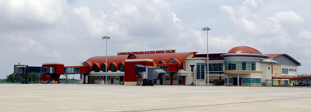
Sultan Abdul Halim Airport (Alor Setar)
IATA/ICAO code
AOR / WMKA
Latitude
06°11'33.72"N
Elevation
15ft / 5m
Longitude
100°24'8.64"E
Runway
1
Capacity
0.8 mppa
Popularly known as Alor Setar Airport, the Sultan Abdul Halim Airport serves Kedah and its neighbouring states and is located 13 km from Alor Setar town. In 2006, a new terminal was opened and its runway extended to 2,745 km for this this domestic airport. Currently, the airport can handle up to 800,000 passengers annually and has the capacity to meet the needs of Airbus 330 operations.
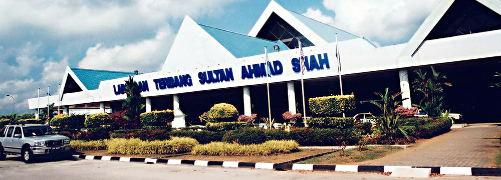
Sultan Ahmad Shah Airport (Kuantan)
IATA/ICAO code
KUA / WMKD
Latitude
03°46'50.3898"N
Elevation
58ft / 18m
Longitude
103°12'52.653"E
Runway
1
Capacity
1.3 mppa
Also known as Kuantan Airport, the Sultan Ahmad Shah Airport is located 15 km from Kuantan town. The airport also houses the 6th Squadron and 19th Squadron of the Royal Malaysian Air Force.
Sultan Azlan Shah Airport (Ipoh)

IATA/ICAO code
IPH / WMKI
Latitude
03°34'13.731"N
Elevation
130ft / 40m
Longitude
101°05'52.9614"E
Runway
1
Capacity
0.5 mppa
Sultan Azlan Shah Airport is an airport that serves Ipoh, a city in the state of Perak, Malaysia. It is located 6 km away from the city centre. Sultan Azlan Shah Airport has been ranked as the seventh busiest airport in Malaysia.
Sultan Ismail Petra Airport (Kota Bharu)

IATA/ICAO code
KBR / WMKC
Latitude
06°10'05.1738"N
Elevation
16ft / 5m
Longitude
102°17'36.6432"E
Runway
1
Capacity
1.5 mppa
Formerly a British RAF military base, Sultan Ismail Petra Airport was relocated to a new terminal in 2002. It serves the city of Kota Bharu and the state of Kelantan. In 2011, the runway was extended to 2,400 m to accommodate the operation needs of Airbus A330 and Boeing 737-800. It also houses the Asia Pacific Flight Training flying school.
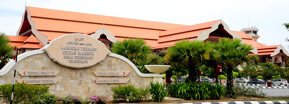
Sultan Mahmud Airport (Kuala Terengganu)
IATA/ICAO code
TGG / WMKN
Latitude
05°22'49.2738"N
Elevation
21ft / 6m
Longitude
103°06'25.056"E
Runway
1
Capacity
1.5 mppa
Sultan Mahmud Airport serves the city of Kuala Terengganu and the state of Terengganu. It is located 15 km from Kuala Terengganu town and handles more than 900,000 passengers annually. It has a single runway of 3,480 m in length and apart from domestic flights also handles flights to Jeddah and Mecca, during the annual Hajj pilgrimage.
Bintulu Airport
IATA/ICAO code
BTU / WBGB
Latitude
03°07'25.86"N
Elevation
74ft / 23m
Longitude
113°01'13.70"E
Runway
1
Capacity
1.0 mppa
Opened in 2002, Bintulu Airport now serves the town of Bintulu as well as the state of Sarawak. Located 5.5 km from Bintulu town, the airport has a single runway measuring 2,745 m and is able to handle aircraft as large as the Boeing 747.
Limbang Airport

IATA/ICAO code
LMN / WBGJ
Latitude
04°48'29.89"N
Elevation
14ft / 4m
Longitude
115°00'37.58"E
Runway
1
Capacity
0.25 mppa
Reopened in 2004, Limbang Airport serves the town of Limbang and the state of Sarawak. Formerly a Short Take-Off and Landing (STOL) port, the airport is 6 km from Limbang town and is capable of handling 250,000 passengers annually with a single runway measuring 1,500 m.
Miri Airport

IATA/ICAO code
MYY / WBGR
Latitude
04°19'19.25"N
Elevation
59ft / 18m
Longitude
113°59'12.50"E
Runway
1
Capacity
2.0 mppa
Miri Airport is the second busiest airport in Sarawak. Located close to the border of Brunei, it serves the city of Miri and the northern region of Sarawak. The airport has the capacity to handle 2 million passengers per year.
Mulu Airport

IATA/ICAO code
MZV / WBMU
Latitude
4°3'03" N
Elevation
80ft / 24m
Longitude
114°48'56" E
Runway
1
Capacity
0.05 mppa
Mulu Airport serves the area of Mulu in Sarawak. The airport is located 2.4 km from Mulu town and is the main gateway to the Gunung Mulu National Park. The airport has a 1,500-metre long runway and operates from dawn to 4pm daily. Although a small airport with basic facilities, it has a VIP Lounge, some retail and F&B outlets as well as hotel booking facilities for the convenience of travellers.
Mukah Airport

IATA/ICAO code
MKM/ WBGK
Latitude
02°52'55.8"N
Elevation
20.14ft / 6.14m
Longitude
112°02'36.38"E
Runway
1
Capacity
0.26 mmpa
Mukah Airport (IATA Code: MKM) was officially open on 17 June 2021 to replace the older Mukah STOLport. The airport serves the coastal town of Mukah in Sawarak.
Through this airport, the surrounding community are assured of proper transportation connectivity to ensure smooth and seamless logistical support for necessities.
The airport can handle up to 264,000 passengers per annum and is capable of handling three Twin-Otter aircraft and three helicopters simultaneously.
Sibu Airport

IATA/ICAO code
SBW / WBGS
Latitude
02°15'41.77"N
Elevation
122ft / 37m
Longitude
111°59'07.16"E
Runway
1
Capacity
1.8 mppa
A former military airfield, Sibu Airport was remodelled into a full-fledged commercial airport in 1962 with a single runway of 2,745 m in length. Located 22.5 km from Sibu town, it serves both the states of Sabah and Sarawak. In August 2012, the new terminal, which can accommodate up to 1.8 million passengers annually, was opened to cater to the increasing number of business and leisure passengers to Sibu.
Labuan Airport

IATA/ICAO code
LBU / WBKL
Latitude
05°17'28.7592"N
Elevation
101ft / 31m
Longitude
115°14'45.2718"E
Runway
1
Capacity
2.2 mppa
Opened in 1999, Labuan Airport serves the town of Labuan and the state of Sabah. Located 2 km from the town centre, the airport can accommodate larger aircrafts such as the Boeing 777 and the Airbus A330. It can handle up to 2.2 million passengers per year.
Lahad Datu Airport

IATA/ICAO code
LDU / WBKD
Latitude
05°01'43.6728"N
Elevation
45ft / 14m
Longitude
118°19'44.6946"E
Runway
1
Capacity
0.1 mppa
The Lahad Datu Airport is located 1km from Lahad Datu town and is able to accommodate Fokker 50s and smaller commuter aircraft. Lahad Datu Airport now offers enhanced facilities and is equipped to handle 100,000 passengers annually.
Sandakan Airport

IATA/ICAO code
SDK / WBKS
Latitude
05°53'51.0426"N
Elevation
46ft / 14m
Longitude
118°03'42.0906"E
Runway
1
Capacity
1.5 mppa
Sandakan Airport is located 13 km from Sandakan town. The terminal building and its runway was last upgraded in 2014 and has the capacity to handle 1.5 million passengers annually. The airport is a major tourism gateway to numerous eco destinations within Sabah. Sepilok Orang Utan Rehabilitation Centre is amongst the top tourist attraction in Sabah. Other great attractions near Sandakan Airport are Gomantong Caves, Kinabatangan River, Labuk Bay Proboscis Monkey Sanctuary, Turtle Island and the very long canopy walk at the Rainforest Directory Centre.
Tawau Airport

IATA/ICAO code
TWU / WBKW
Latitude
04°15'45.8994" N
Elevation
57ft / 17m
Longitude
117°53'5.514"E
Runway
1
Capacity
1.5 mppa
Officially opened in December 2001, Tawau Airport is the second largest airport in Sabah. It is situated 31 km from Tawau and serves the city as well as surrounding areas. The new terminal was built to cater to the growing number of tourists headed to marine and natural parks located near Tawau. Its runway is 3,000 m in length.
Pangkor STOLport

IATA/ICAO code
PKG / WMPA
Latitude
4°14'41"N
Elevation
19ft / 5.8m
Longitude
100°33'12"E
Runway
1
Pangkor STOLport is situated on Pangkor Island, a popular tourist attraction off the coast of Perak. It is our corporate responsibility airport and as such passengers departing from this STOLport do not have to pay any passenger service charges.
Redang STOLport

IATA/ICAO code
RDN / WMPR
Latitude
5°45'55"N
Elevation
10ft / 3m
Longitude
103°0'25"E
Runway
1
Redang STOLport is located on Redang Island, off the east coast of Penisula Malaysia. This airport is run on a corporate responsibility basis to ensure that people in rural or remote areas are assured of transportation connectivity and basic needs. As such, passengers departing from this STOLport do not have to pay any passenger service charges.
Tioman STOLport

IATA/ICAO code
TOD / WMBT
Latitude
2°49'8"N
Elevation
13ft / 3.9m
Longitude
104°9'36"E
Runway
1
Tioman STOLport is located in Tekek Village on Tioman Island. The island is off the south-east coast of Peninsula Malaysia, just north of the Johor-Pahang state borders. This airport is run on a corporate responsibility basis to ensure that people in rural or remote areas are assured of transportation connectivity and basic needs. As such, passengers departing from this STOLport do not have to pay any passenger service charges.
Bakelalan STOLport

IATA/ICAO code
BKM / WBGO
Latitude
3°58'10.5594"N
Elevation
2900ft / 884m
Longitude
115°36'50.3992"E
Runway
1
Bakelalan STOLport serves the rural area of Bakelalan in Sarawak. This airport is run on a corporate responsibility basis to ensure that people in rural or remote areas are assured of transportation connectivity and basic needs. As such, passengers departing from this STOLport do not have to pay any passenger service charges.
Bario STOLport

IATA/ICAO code
BBN / WBGZ
Latitude
3°44'2.004" N
Elevation
3,350 ft / 1,021m
Longitude
28°44'3992" E
Runway
1
Bario STOLport serves the rural area of Bario in Sarawak. This airport is run on a corporate responsibility basis to ensure that people in rural or remote areas are assured of transportation connectivity and basic needs. As such, passengers departing from this STOLport do not have to pay any passenger service charges.
Belaga STOLport

IATA/ICAO code
BLG / WBGC
Latitude
2°38'59.9994" N
Elevation
200ft / 61m
Longitude
113°46'1.1994" E
Runway
1
Belaga STOLport serves the small town of Belaga in Sarawak. This airport is run on a corporate responsibility basis to ensure that people in rural or remote areas are assured of transportation connectivity and basic needs. As such, passengers departing from this STOLport do not have to pay any passenger service charges.
Kapit STOLport

IATA/ICAO code
KPI / WBGP
Latitude
2°0'30.1674" N
Elevation
65ft / 20m
Longitude
112°55'48" E
Runway
1
Kapit STOLport serves the rural area of Kapit in Sarawak. This airport is run on a corporate responsibility basis to ensure that people in rural or remote areas are assured of transportation connectivity and basic needs. As such, passengers departing from this STOLport do not have to pay any passenger service charges.
Lawas STOLport

IATA/ICAO code
LWY / WBGW
Latitude
4°50'57.0114" N
Elevation
7ft / 2m
Longitude
115°24'28.8" E
Runway
1
Lawas STOLport serves the rural area of Lawas in, Sarawak. This airport is run on a corporate responsibility basis to ensure that people in rural or remote areas are assured of transportation connectivity and basic needs. As such, passengers departing from this STOLport do not have to pay any passenger service charges.
Long Akah STOLport
IATA/ICAO code
LKH / WBGL
Latitude
3°17'59.9994" N
Elevation
289ft / 88m
Longitude
114°46'58.8" E
Runway
1
Long Akah STOLport serves the rural area of Long Akah in Sarawak. This airport is run on a corporate responsibility basis to ensure that people in rural or remote areas are assured of transportation connectivity and basic needs. As such, passengers departing from this STOLport do not have to pay any passenger service charges.
Long Banga STOLport

IATA/ICAO code
LBP
Latitude
3°11'5.82" N
Elevation
751ft / 229m
Longitude
115°27'14.3994" E
Runway
1
Long Banga STOLport serves the rural area of Long Banga in Sarawak. This airport is run on a corporate responsibility basis to ensure that people in rural or remote areas are assured of transportation connectivity and basic needs. As such, passengers departing from this STOLport do not have to pay any passenger service charges.
Long Lellang STOLport

IATA/ICAO code
LGL / WBGF
Latitude
3°25'15.5994" N
Elevation
1400ft / 457m
Longitude
115°9'14.3994" E
Runway
1
Long Lellang STOLport serves the rural area of Long Lellang in Sarawak. This airport is run on a corporate responsibility basis to ensure that people in rural or remote areas are assured of transportation connectivity and basic needs. As such, passengers departing from this STOLport do not have to pay any passenger service charges.
Long Semado STOLport

IATA/ICAO code
LSM / WBGD
Latitude
04°12′59″N
Elevation
2,150ft / 655m
Longitude
115°34′58″E
Runway
1
Long Semado STOLport serves the rural area of Long Semado in Sarawak. This airport is run on a corporate responsibility basis to ensure that people in rural or remote areas are assured of transportation connectivity and basic needs. As such, passengers departing from this STOLport do not have to pay any passenger service charges.
Long Seridan STOLport

IATA/ICAO code
ODN / WBG
Latitude
3°58'1.2" N
Elevation
607ft / 185 m
Longitude
115°2'59.9994" E
Runway
1
Long Seridan STOLport serves the rural area of Long Seridan in Sarawak. This airport is run on a corporate responsibility basis to ensure that people in rural or remote areas are assured of transportation connectivity and basic needs. As such, passengers departing from this STOLport do not have to pay any passenger service charges.
Marudi STOLport

IATA/ICAO code
MUR / WBGM
Latitude
4°10'65" N
Elevation
102ft / 31m
Longitude
114°19'32" E
Runway
1
Marudi STOLport is one of the busiest STOLports in Sarawak and is located near Marudi town. This airport is run on a corporate responsibility basis to ensure that people in rural or remote areas are assured of transportation connectivity and basic needs. As such, passengers departing from this STOLport do not have to pay any passenger service charges.
Kudat STOLport

IATA/ICAO code
KUD / WBKT
Latitude
6°55'21"N
Elevation
10ft / 3m
Longitude
116°50'9.5994"E
Runway
1
Kudat STOLport serves the small town of Kudat in Sabah. The STOLport is located 7 km from Kudat town. This airport is run on a corporate responsibility basis to ensure that people in rural or remote areas are assured of transportation connectivity and basic needs. As such, passengers departing from this STOLport do not have to pay any passenger service charges.
Long Pasia STOLport

IATA/ICAO code
GSA / WBKN
Latitude
4°24'57"N
Elevation
968ft / 295m
Longitude
115°43'13"E
Runway
1
Long Pasia STOLport serves the small town of Long Pasia in Sabah. This airport is run on a corporate responsibility basis to ensure that people in rural or remote areas are assured of transportation connectivity and basic needs. As such, passengers departing from this STOLport do not have to pay any passenger service charges.
Semporna STOLport
IATA/ICAO code
SMM / WBKA
Latitude
4°26'59"N
Elevation
60ft / 18m
Longitude
118°35'47"E
Runway
1
Semporna STOLport serves the small town of Semporna, in Sabah. This airport is run on a corporate responsibility basis to ensure that people in rural or remote areas are assured of transportation connectivity and basic needs. As such, passengers departing from this STOLport do not have to pay any passenger service charges.
Istanbul Sabiha Gökçen Airport

IATA : SAW, ICAO LTFJ
Latitude
40°53'54" N
Elevation
312ft / 95m
Longitude
29°18'33" E
Runway
1
Capacity
41 mppa
Opened in 2001, Istanbul Sabiha Gökçen International Airport (IATA Code: SAW) is one of three international airports serving Turkey’s largest city, Istanbul. Malaysia Airports involvement in SAW begun in 2008 in the planning and development of its new terminal.
Following the full acquisition of SAW in 2014, Malaysia Airports is now responsible for the operation, management, development and provision of airport-related services at SAW. Our strategies are focused towards customer satisfaction, operational excellence, capacity expansion, employee development and enhancing profitability.
Ranked as one of Europe’s top five busiest airports, SAW is approximately 32km away from the city centre, built for a capacity of 41 million passenger per annum (mppa) with one runway at approximately 3,000m in length. Another runway is currently being constructed with a length of approximately 3,500m and is expected to be completed in 2021.
An environment-friendly structure, Istanbul Sabiha Gökçen International Airport was built with a modern design that was benchmarked by international standards. It is a passenger-friendly airport, containing a total of 160 check-in counters, 76 aircraft parking stand, a huge variety of retail and duty-free outlets, cafes, restaurants and a two-storey VIP building connecting to the terminal as well as a three-storey 128 rooms airport hotel adjacent to the terminal. Renovations at SAW were completed in 2018 which would allow the airport to operate at a higher capacity and allowed the airport to change its business focus from domestic to international passengers which will enable the airport to provide better services to passengers while benefiting SAW with higher revenues.
Istanbul Sabiha Gökcen International Airport was the world’s fastest growing airport for seven consecutive years and it has been recognised as the “Large Airport of the Year” at 2019 CAPA Global Aviations Awards for Excellence and most recently as the at ACI Europe Best Airport Award 2020, SAW is also recognised as “Highly Commended” in the Best Airport Award.